Weather Classroom: Pileus Clouds
Pileus clouds, or cap clouds, often appear above intensifying thunderstorms.
On Monday night, atop developing thunderstorms over western Iowa, sky watchers in the Omaha area were treated to an example of pileus clouds, which added to the visual presentation of tall, billowing white clouds that were beginning to also reflect oranges and pinks in the setting sun.
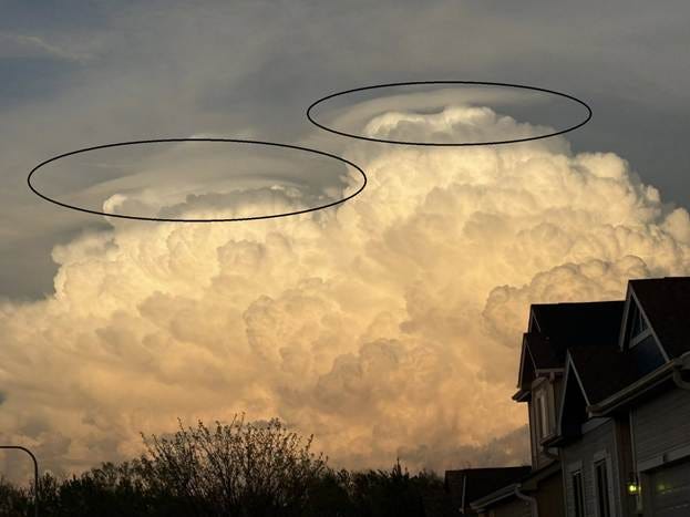
What are pileus clouds, how do they form, and what do they signify in the atmosphere?
Etymology:
Pileus, or pilos in Greek, was a brimless, conical cap worn in Ancient Greece common among travelers and often associated with liberty, per the 2007 book ‘Greek and Roman Dress from A to Z’, authored by Liza Cleland and others. Pileus clouds – also known as cap clouds – are given the name because of the appearance that the cloud is wearing a saucer-shaped cap, with condensed air flowing over the top of the broader, billowing cloud below.
Physics:
Developing thunderstorms are not unlike mountains in terms of how surrounding air will behave as the flow encounters the new storm’s core updraft. Another appropriate analogy is when a rock protruding above a riverbed forces the flow of the water to either continue around or above the obstruction. The updraft, air parcels soaring upwards in the sky and are understood visually by the broad and puffy white clouds in the picture above, creates a disruption to normal atmospheric flow with its upward transportation of atmospheric mass to the upper atmosphere. Background airflow, which had been traveling in a defined pattern before the development of the updraft, must now – like river flow approaching a rock - adjust to the presence of an obstruction. Some of this air flows over the new updraft.
Let’s take a closer look at the picture above.
Updrafts exist in three dimensions and though they can come in all shapes and sizes, we will assume for this explanation that this updraft is mostly circular. In this example, the wind is traveling into the picture, which for this case was from west to east. We are looking at the direction from which the wind is impacting the updraft. Curvature appears in the cloud because the central portion of the pileus cloud is the first air parcel to encounter this updraft, just as the closest point of a conical pilos cap would be in the middle of the cap.
Pileus clouds appear when this upward adjustment of airflow takes the air parcel upward to the point in the atmosphere where the temperature is cool enough for the air to condense into visible water droplets. These droplets are visible as clouds during the short period of time while they are forced to travel over the updraft.
When the air is forced upward, it is forced into a layer of atmosphere that already has its own flow, such as a car being forced to merge into an already busy lane of traffic. This air will return to its own layer of atmosphere as soon as it is physically able. When the flow has passed the peak of the updraft, it descends back to the original layer with which it was flowing. The combination of ascent and descent gives the appearance of a cap or a hat. As the airflow descends, it finds its original air temperature, at which condensation is not occurring. At that point, the visible appearance of the cloud ends. This process can repeat multiple times as the updraft grows, with a close examination showing multiple, perhaps several parallel pileus clouds near each other.
How do pileus clouds evolve with time? Pileus clouds are often very short-lived, but some changes in their appearance can be noted with close observation.
Updrafts are very rarely stationary. Usually, updrafts possess some horizontal motion over the course of several minutes, and often they continue to grow during the pileus cloud stage of their life cycle as well. As they develop vertically and move past the location where the pileus clouds have developed, the clouds will appear more as a ring than as a cap.
Significance:
Pileus clouds can signal an increasing intensity of the updraft, and as was the case on 28 April in western Iowa, they can signal that a benign updraft that was not even producing rain is beginning to develop into a severe thunderstorm. Pileus clouds indicate that the vertical motion within the updraft is strong enough that the surrounding atmospheric flow must make sudden changes to its path. Meteorologists who are issuing warnings for thunderstorms in an area are looking for any clues that updrafts are becoming more vigorous, especially for clouds that have already existed harmlessly for an hour or two but are now rapidly changing.
Pileus clouds should be avoided by aircraft. The sudden changes in airflow create a turbulent flow that the aircraft can feel, and the presence of pileus clouds indicates liquid droplets in the atmosphere at levels that are usually below 0 degrees Celsius. In a sub-freezing atmosphere, droplets attach to the aircraft and freeze, which creates extra weight for the aircraft to account for. Though pileus clouds are thin and short-lived and large aircraft almost always can account for some ice accumulation, it is simply more optimal to avoid the cloud entirely.
Predictability:
Pileus clouds are not predictable given the nature of current observations and forecast capabilities. They are not uncommon with strong updrafts, however, and can usually be expected, at least briefly, when strong thunderstorms are expected.